Rodney G., a reader of this blog noticed a new feature in
Google Maps. "When you search for a city or a county or a ZIP Code, Google Maps now highlights the boundaries of what you searched for. If you are zoomed out, the whole area is shaded pink. If you zoom in a bit, it has just a big pink border with grey shading. Zoom in even more and it's a dashed boundary with grey shading."
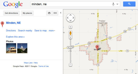
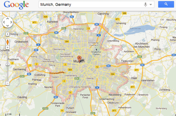
It's a really useful feature and the nice thing is that's enabled by default. Just search for a country, a city, a state or a ZIP code and Google Maps will automatically highlight it.
{ Thanks, Rodney. }

This is a great feature - I've always found it unsatisfying when I search on a large geographical region (e.g. austria) and get a map with borders t hat are hard to discern.
ReplyDeleteHaving just now tried the feature I note that it doesn't work everywhere. It works for Switzerland, France, Ontario, and Toronto, but not for Israel or Egypt!
Works for Israel!
DeleteYeah, it works for Colombia, Argentina, Chile, Ecuador, Peru, but not for Venezuela...
ReplyDeleteIn fact, Venezuela is the only South American country that doesn't work with the pink border... weird.
ReplyDeleteIt doesn't necessarily work everywhere within a country - For example in the UK, London Derby and Leicester have a boundary whereas Manchester, Birmingham Newcastle and Nottingham (which are larger cities) do not.
ReplyDeleteI believe this could be due to the boundaries that are shown are related to administrative boundaries. Manchester, Birmingham, Newcastle and Nottingham have different local government (council) areas covering what we commonly identify as the whole city.
Oh, check this out -- you can overlay areas! For instance, search for Charlotte, NC. Then search for Mecklenburg County, NC. It will remove the Charlotte and show you the Mecklenburg. But now you can go up to the pulldown on the upper-right (where Traffic, Weather, Photos are) and select your previous search. Now it shows both areas overlayed.
ReplyDeleteThe UK post codes I've tried (mid-Sussex) return a marked area but it is not correct, e.g. I know the post code represents all addresses on one side of a road, but the area marked is roughly circular at the mid-point of the road.
ReplyDeleteawesome feature there...it make life easier for laymen people ..
ReplyDeleteWould be even more interesting to highlight as a mask
ReplyDeleteExample here: http://www.vasile.ch/hacks/ft-mask/map.html
It doesn't work for me (I live in Brazil). Even if I search for ANY Brazilian or non-Brazilian city
ReplyDeletewould be awesome to be able to do that in google maps as well, like
ReplyDeletemap.highlightArea( { location: "Europe" } );
by "google maps" i mean "google maps js API"
Deleteyes, that would be awesome
Deleteyes, that would be awesome
DeleteLooking at these responses, we can't do this by default on google Maps JS API?
DeleteWondering if now that is available ....
DeleteThis method for highlight works. The data set is greatly reduced for jsfiddle so if you zoom in you see deteriation in the plot. Give it a few seconds to load.
Deletehttp://jsfiddle.net/chrisloughnane/CSGWM/1/
Great. But how did you get the county boundaries in the first place? You're not using the API to get those.
DeleteThat doesnt work in Brazil..
ReplyDeleteFor me, it works in Brazil too, if I use maps.google.co.uk or .hu, but not on .com - maybe some datacenters of Google have it already, while others do not.
ReplyDeleteIt's working in Brazil! \o/
ReplyDeleteHOw to implement this feature using google maps api v3 ?
ReplyDeleteyaps, that's right, how to use this feature in google maps api v3?
DeleteDoes anyone know about any official documentation on this?
ReplyDeleteCan you export or save the boundary information so that it display on a custom map. (e.g. "Save to My Maps")
ReplyDeleteAdam Omer El Safi Manzul (Adam El Safi)
ReplyDeleteSudan + 249900306152
abumaaimrani20049@gmail.com
ادم عمر الصافي منزول
ReplyDelete(Adam El Safi)
السودان +249900306152
abumaaimrani200469@gmail.com
It is amazing and wonderful to visit this site. I've learn many things from this site.
ReplyDeleteBuy Flat Earth Map