* Select one or more places from the map.
* Draw lines and polygons to highlight paths and areas.
* Add descriptions by typing HTML code or using a rich text editor.
* More in this user guide.
Each map will have its own permalink (like this map of Googleplex) and can be exported as KML to see it in Google Earth. Google wants to create a big directory of maps, so if you decide to make your map public, anyone can find it in the search results. The alternative is to make it unlisted, which means the address won't be included in search results, but it will be accessible to anyone who knows it (much like in Picasa Web).
You can find maps created by other people if you search for a local business and click on "see user-created content" at the bottom of the search results. This acts as a search engine for KML files available on the web, so you'll find a lot of KML files from bbs.keyhole.com (Google Earth Community), where you could host your KMLs and get some feedback.
This new feature (available for a long time in Windows Live Maps or in some Google Maps mashups) is also a good way to share more than one place with a single link. You can add placemarks manually or from the search results.

Ahhh!!! This is just awesome. Exactly what I was looking for. I only hope Google comes up with more icons for the locations. I love it. Love it. Love it.
ReplyDeleteThis is great new feature! I'll be using it. Extensively
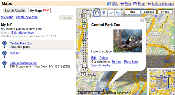
ReplyDeleteNote: the Central Park Zoo is actually here
(not on the east side as shown in your screen shot)
Awesome!! Big fan of Google. Hopefully google developers see this.
ReplyDeleteIdeas:
**How about allowing a group of people to edit a group map, something like wiki. Either public, or password protected.
Example: I'm in a photography group and would be great to create a public "map" with interesting places to take photos.
**Import KMLs.
**Simple way of search public maps/KMLs. (From google search such as filetype:kml, so something like MAP: Toronto)
I have a geographically organized database with several hundred entries. Importing is a vital feature. I'm not going to embrace My Maps until that's possible.
ReplyDeleteThe other problem is that adding locations to one map at a time isn't sophisticated enough. If I'm record the location for a restaurant I would want it to appear on a Thai food map, a Vietnamese food map, a restaurant map and a general food map.
I have tried drawing a route with the line command, but have been unable to get it to print. Hopefully, Google will fix this in the future.
ReplyDelete** Importing KMLs **
ReplyDeleteGoogle Maps can render some KMLs: just type the URL in the search box. So it won't be too difficult to add an important feature.
** How to find KMLs **
filetype:kml actually works in Google search, but it would be nice to have a link "view in Google Maps". Right now, if you have Google Earth and click on a link to a KML file, it will open in Google Earth.
** Wiki Maps **
That would be really nice. Until they add it, try WikiMapia.
** Printing maps **
You can print screen the map and print the image from Paint or an image editor. Or save the KML and open it in Google Earth.
I think a lot of companies just saw their value proposition disappear.
ReplyDeleteDeath by Google strikes again!
I have over 150 pins set and would like to see them all on one map rather than paging through several pages. I this being worked on?
ReplyDeleteGreat possibilities here.
This is awesome! Now to make it better.....add the capability to upload PHOTOS!
ReplyDeleteAllowing labels to be displayed for the icons chosen would be nice.
ReplyDeleteEven better is to either roll-over them for display of a static display the user can control as a layer.
i think both the My Maps feature and the new terrain feature will be extremely useful tools for land surveyors...
ReplyDeleteSimply tried to add the marker to a part of SE Asia and when opening the preview box map pane had either jumped out of focus (just some 100 - 120 miles, who cares) or the zoom factor had changed significantly.
ReplyDeleteWhen saving the map and cutting and pasting the generated iframe code of the whole map defaulted to North America.
?????
I think this application still needs some serious testing.
Hi,
ReplyDeleteIs there any API for this personalized maps. so that other site owners can use this feature in there own site.
kiran
Kiran101 I believe that Google maps charges for that feature.
ReplyDeleteHey i can only add 1 location from 1 Google account.
ReplyDeleteplease suggest.
Would there be a way to merge addresses from a Google doc into the map? That would be very useful to us! :) Great feature in any case!
ReplyDeleteHi,
ReplyDeleteI have a link of my data in google map, i want to share with any people.
How to do?
Regards,
Hi every body,
ReplyDeleteI have a data in Google map, but i would like to share my data with every people when they want to know in google search.
But i don't know how to do, Please help me to explain the step by step.
Many thanks,