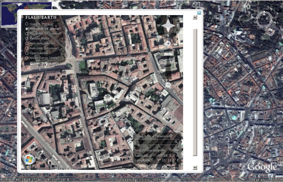
You've probably heard about
FlashEarth, the site that lets you compare the satellite imagery offered by Google Maps, Yahoo Maps, Microsoft Virtual Earth, Ask.com and more. Now you can use FlashEarth directly from Google Earth
thanks to a layer created by Barry Hunter. "As you move around the globe a little white arrow follows you around, simple click it to get an approximation of the current view in FlashEarth in a popup balloon."
This could be useful if Google Earth doesn't have a very good coverage of a certain area or you just want to see the same image from a different perspective.


[O.T.] Hi. I noticed that you often use the city of Milan in your aerial screenshot. Do you live here?
ReplyDeleteNo, and I don't remember using other images related to Milan or Italy.
ReplyDelete@manuel- ionut doesn't actually live anywhere, or even exist as a human entity for that matter.
ReplyDeleteIf the two images were taken from different perspectives, would it be possible to superimpose the two images to provide a pseudo 3-d image of the city scape?
ReplyDeletehttp://en.wikipedia.org/wiki/Stereogram
Es un programa que esta bien
ReplyDeleteThose picture have nothing to do with Milan. Looks like it's Poland or so.
ReplyDeleteis it possible to capture the website as a large image file?how?
ReplyDelete